
Right-click menu
Right-click the map to open a menu of actions for that spot. On a touch screen, press and hold the map instead.
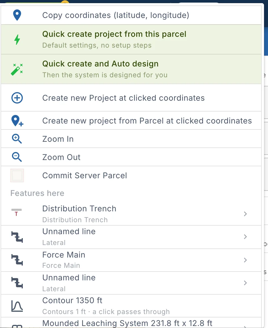
The menu shows only what applies where you clicked:
| Part | Shown |
|---|---|
| Copy coordinates, Zoom In, Zoom Out | Always. |
| Quick create and Create new Project | Always, to start a project at that spot. |
| Show county GIS layers here | With no project open. |
| Commit items | Over a parcel that isn't the project's yet. |
| Soil boundary actions | Over a soil boundary. |
| Features here | Over features you can select. |
In print mode the menu lists only the features here, to change their label or look.
Create a project here
Right-click the parcel you want to design on, and choose one of:
| Item | What it does |
|---|---|
| Quick create project from this parcel | Creates the project with your default settings and no setup steps. Over an empty spot it reads Quick create project here. |
| Quick create and Auto design | Creates the project the same way, then Auto design designs the system. See Smart Design and Auto Design. |
| Create new Project at clicked coordinates | Opens Create project on the parcel search at that spot, so you can check the parcel and set up the project. |
| Create new project from Parcel at clicked coordinates | The same, shown over a parcel from the county data. |
See Start a project.
Copy coordinates and zoom
Copy coordinates (latitude, longitude) copies the latitude and longitude of the spot you clicked, to paste into a message, a form or the search bar.
Zoom In and Zoom Out zoom the map in or out one step.
County GIS layers
With no project open, Show county GIS layers here adds the GIS layers of the county at that spot to the map.
- The message says how many of the county's layers were added.
- The map zooms in: county layers show from zoom 17. Find them in the Layers panel.
- If the county has no layers yet, the message says so.
Commit parcels
A parcel becomes the project's parcel when you commit it. Committing adds its outline and setback buffers to the design. Right-click inside the parcel and choose:
| Item | Shown when |
|---|---|
| Commit Drawn Parcel | You drew the parcel with the Parcel tool. |
| Commit Server Parcel | The parcel comes from the county parcel data. |
| Commit all Parcels at clicked coordinates | More than one parcel is at that spot. |
The Commit window then asks how to use the parcel. See Change project parcels.
Soil boundary actions
Right-click a soil boundary, drawn or from the NRCS soil survey, to design in it. The menu shows the boundary's name and three actions:
| Item | What it does |
|---|---|
| Check fit along contour | The longest usable contour in the boundary, and which systems fit. |
| Design system in this soil boundary | Pick a system that fits and place it on the contour. |
| Auto design in this soil boundary | The system that fits best, designed for you. |
See Check fit along contour and Design in a soil boundary.
Features here
Features here lists every feature under the pointer, the top one first. It is the way to reach a feature hidden under another, such as a pipe under a bed.
Each row shows the feature's name and its layer, for example Force Main · Force Main or a parcel's number and Parcels. A click passes through means a click on the map goes past that feature to the one below it.
- Point at a row to outline that feature on the map.
- Click a row to select the feature, as Select would. The select tool turns on if it was off.
- Click the arrow at the end of a row for the feature's actions.
Feature actions
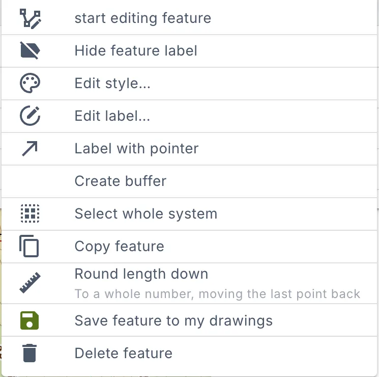
The arrow at the end of a row in Features here opens the actions for that feature.
| Action | What it does |
|---|---|
| Start editing feature / Stop editing feature | Move the feature's points. |
| Hide feature label / Show feature label | Hide or show its label on the map. |
| Edit style… | Change its colour, line and fill. See Styling layers. |
| Edit label… | Change its label: the text, size and colour. |
| Label with pointer | Move the label away from the feature, with a line back to it. Drag the label to where it reads best. Once set, it reads Move label…. |
| Create buffer | Draw a buffer around the feature. See Buffer. |
| Select whole system | Select the septic system the feature belongs to, to move or rotate it as one. Shown for system parts. See Move or rotate a whole system. |
| Copy feature | Copy it and paste it into a layer. See Copy feature. |
| Use as residence (Building With Flow) | Make a building the house the system serves. Shown for buildings. |
| Flip building left to right / Flip building top to bottom | Mirror a building. Shown for buildings you can edit. |
| Round length down | Shorten a line to a whole number, moving its last point back. |
| Save feature to my drawings | Save it to reuse in other projects. See Saved features. |
| Delete feature | Delete it. |
On a soil boundary the actions start with the soil boundary actions. On a phone, the actions open in a window.