
Parcel search
One search box finds places, addresses, parcel IDs and coordinates. Type what you have, and the search works out what it is. From a result you can zoom the map to it, or start a project on it.
Open the search
The search box floats at the top left of the map. It reads Search places, parcels or coordinates.
- Click the box, or press / anywhere on the map page.
- Or press Ctrl+K (⌘+K on a Mac).
The same search is in the New project window, where it reads Address, parcel ID or coordinates. There, the results pick the parcel of the new project. See Find the property.
As you type, the search tells you what it thinks you typed, for example Looks like an address or Looks like a parcel ID. To search for one kind of thing only, click a chip under the box:
| Chip | Searches |
|---|---|
| All | Whatever the text looks like. This is the default. |
| Places | Addresses, businesses, landmarks and towns. |
| Parcel ID | Parcel IDs only. |
| Coordinates | A latitude and longitude only. |
Results come in groups, such as Places and Parcels. Use the arrow keys to move through them. The footer says ↑ ↓ to choose · Enter opens the highlighted result · Esc closes: press Enter to open the highlighted result, and Esc to close the list.
When the box is empty, it lists your Recent searches. Click one to run it again. Clear recent searches in the footer removes them.
Search by address or place
Type an address, a business, a landmark or a town. For example 1234 Charles Ct, Lexington OH. Text that starts with a house number reads as an address.
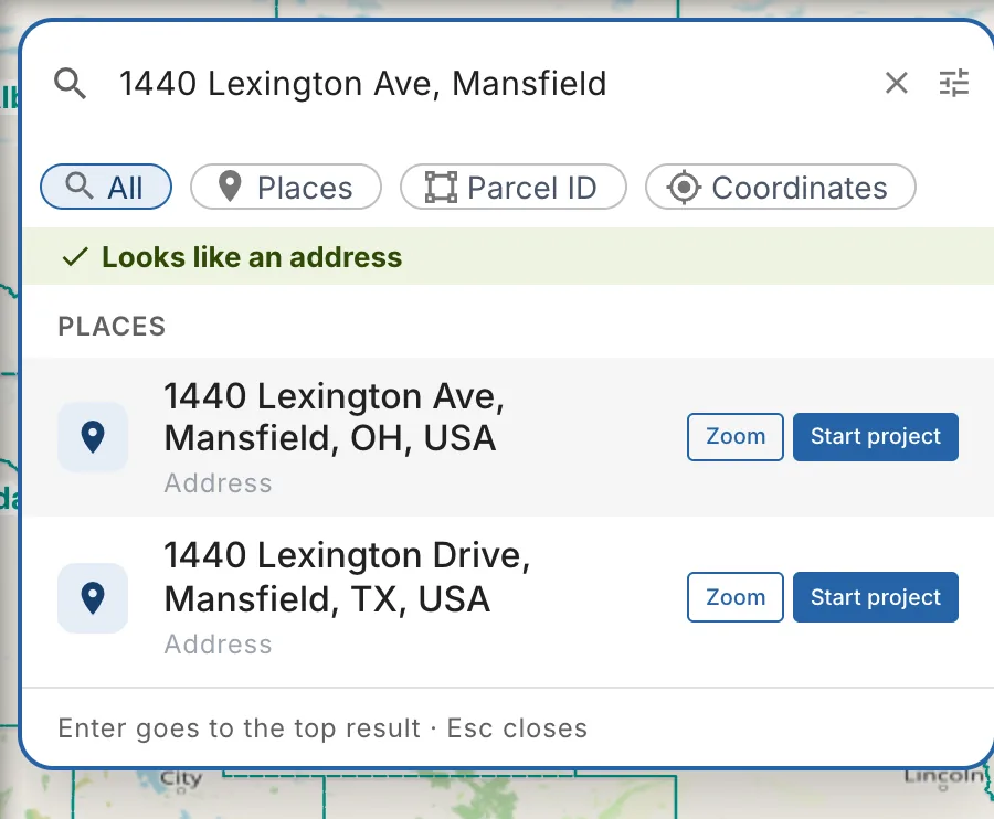
Each place shows what it is: Address, Business or landmark or Place (a town, a road or a region).
- Click a result, or its Zoom button, to move the map to it.
- Click Start project to open the New project window at that address. See Start a project from a result.
A town or a region has Zoom only. A project needs one property, so start it from an address or a parcel.
Search by parcel ID
Type the parcel ID as it is on the tax record, for example 047-26-030-18-008 (a parcel in Richland County, Ohio). An ID of digits with dashes or dots reads as a parcel ID. A five-digit number reads as a ZIP code, so for a short ID, or one with spaces, click the Parcel ID chip first.
Without a county, the search looks near the map view first. When nothing matches there, a whole parcel ID is looked for in the whole state you picked, or everywhere, nearest the map view first. While the map shows a wide area (the whole country when the app opens), there is no "near" yet: a whole parcel ID is looked for everywhere. In the New project window, the search looks near the address you searched there, else everywhere, never near the map behind the window, so you can type the ID without moving the map. The line under the chips says so: Looks like a parcel ID · nearest the map view first. The parcels found are listed under Parcels, with the address, the acres, the owner, the county and how far they are from the map center. When the same ID is found in several places, the list says Parcels with this ID in several places · pick the right one, and none is picked for you.
A short part of an ID (fewer than six letters and digits) matches too many parcels, so it is only looked for within 50 km of the map view.
When the parcel server doesn't answer, the app asks it once more by itself (the first search of an area can be slow). If it still doesn't answer, the list says The parcel search is not answering right now. Try again in a moment, or search the address instead. (or that you seem to be offline), with a Try again button.
When nothing matches, the list says what to try next, with a Pick state and county button right under it:
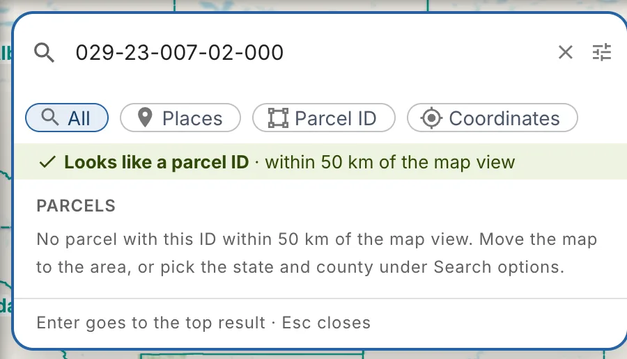
No parcel with this ID in our parcel data. Check the number, search the address instead, or pick the state and county to search that county's records.
To search a county, click Search options (the sliders icon at the right of the box). Under Parcel ID search area:
- Pick USA or Canada.
- Pick the State.
- Pick the County.
The search runs again in that county. The hint under the fields says where it searches, for example Parcel IDs are searched in Richland, OH.
Search by coordinates
Type a latitude and a longitude, latitude first. Both of these work:
- Decimal degrees: 40.7654, -82.5781
- Degrees, minutes and seconds: 40°45'55"N 82°34'41"W
The comma is optional when the two parts can't be mixed up. A pair with the hemisphere letters can be in either order, for example 82.5781W, 40.7654N.
The results show the point under Coordinates, in both forms, and the parcel at that point under Parcel at this point. When there is no parcel at the point, nearby parcels are listed under No parcel at this point · Nearby, each with its distance. Pick one only if it is the right property. Where there is no parcel data at all, the list says No parcel data at this point.
To type the parts in their own fields, open Search options and use Coordinates in separate fields. Choose Decimal degrees or Deg/Min/Sec, fill in Latitude and Longitude with their hemispheres (N/S, W/E), then click Search this point. Use S or W instead of a minus sign.
Use my location
In the New project window, click Use my location (the target icon in the search box). When the box is empty, it is also the first suggestion: Find the parcel where you are standing.
The search finds your position and looks up the parcel there. This works best on a phone or a tablet, standing on the site.
If your browser blocks it, you see Couldn't get your location. Allow location access for this site in the browser settings, or type the address instead.
Find parcels on the map
With no project open, the parcel lines draw only when the map is zoomed in close. Further out, a chip under the search says Zoom in to see parcels.
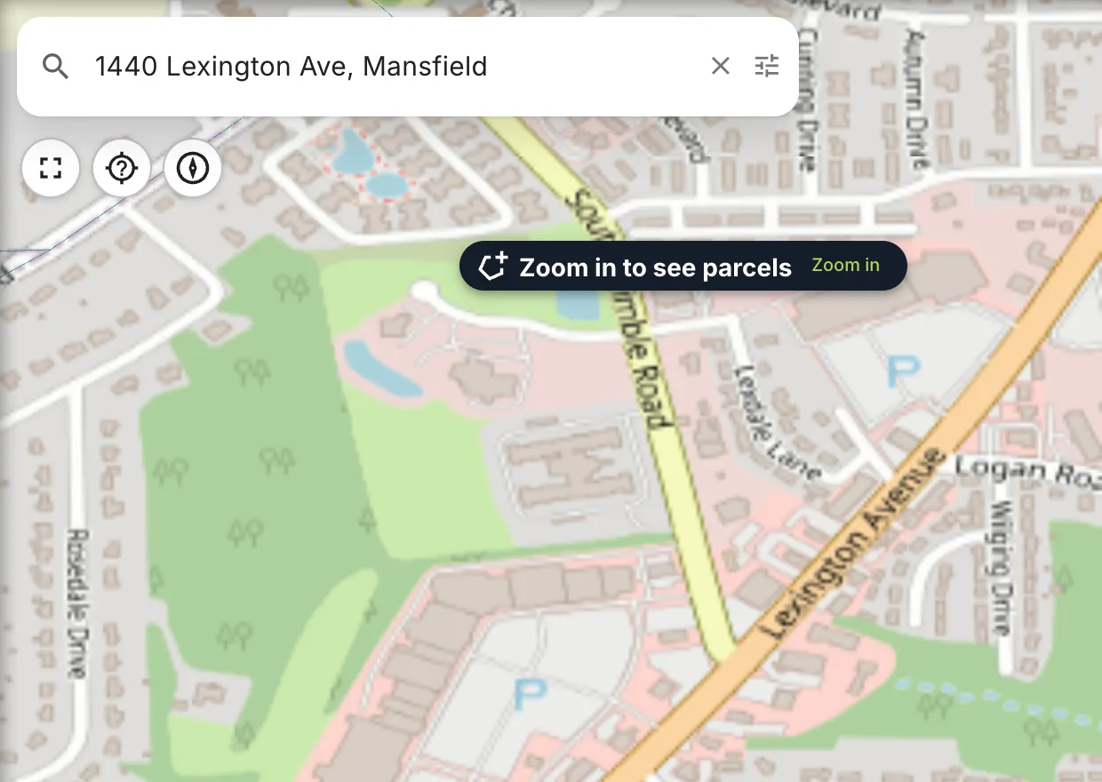
- Zoom in zooms the map to where the parcels draw, keeping the same center.
- Search this area loads the parcels of the view without zooming in further. It shows once the map is close enough, at about zoom 14. If there is no parcel data there, you see No parcels in this area yet.
Once a project is open, its parcel is on the map, and the chip no longer shows.
Start a project from a result
Start project opens the New project window for that result:
- An address or a landmark. The window opens at the address and looks up the parcel there. The first parcel at the point is picked for you.
- A parcel. The parcel is picked, and the window opens on the Setup tab.
- Coordinates. The window opens at the point and looks up the parcel there.
From there, check the parcel, choose how to design the property and create the project. See Quick create or customize.
You can also start a project from a right-click on the map. The menu has:
| Item | What it does |
|---|---|
| Quick create project from this parcel | Creates the project on the parcel under the click, with your default settings. With no parcel there, it reads Quick create project here. |
| Quick create and Auto design | The same, then Auto design drafts the system. |
| Create new Project at clicked coordinates | Opens the New project window at the point, so you can check the parcel and the setup first. |
| Create new project from Parcel at clicked coordinates | Shows over a parcel. Opens the New project window on that parcel. |
| Copy coordinates (latitude, longitude) | Copies the point to the clipboard, to paste in the search or elsewhere. |
When the parcel is missing
Parcel data comes from the counties, and some areas have none yet. In the New project window, the search tells you what it found:
| Message | What to do |
|---|---|
| We don't have parcel data for {area} yet. You can still create the project, then draw or drop in the parcel on the map. | Click Report missing data to tell us about the area. Then click Set up without a parcel or Quick create here to create the project at the point. |
| No parcel at this point. The parcels listed are nearby… | Pick a nearby parcel only if it is the right property. Otherwise click Continue without a parcel, or Report missing data. |
| The parcel search didn't work this time… | The parcel server didn't answer. Click Try again, or create the project and draw the parcel on the map. |
| Not the right parcel? | Shows under the parcels found. Click Continue without a parcel to create the project at the point and draw the parcel yourself. |
Report missing data opens the Contact us form with the area and the point filled in. Click Send message.
A project without a parcel opens at the searched point. Draw the parcel there, or commit one from the map: see Getting accurate parcel information.