Map Tools
One of the core components making up landplan.io is a septic and land planning mapping application. It consists of conglomeration of GIS and general purpose mapping features, interactions and controls to help user fully create, edit, modify and delete design components.
The tools are grouped in different categories with each category having related tools and functionalities
Feature editor tools
These are features that facilitate editing of map components and they include the tools below;
| Number | Tool Name | Icon on Map | Description |
|---|---|---|---|
| 1 | Select feature tool | adds the ability to select a feature in the map | |
| 2 | Select all features tool | adds the ability to select all features including the underlying once, in the map | |
| 3 | Select feature(s) by drag box | adds the ability to select feature(s) using a draw/drag box in the map | |
| 4 | Translate/Move feature(s) tool | this tool enables selected features to be moved around the map | |
| 5 | Copy feature tool | this tool enables selected features to be copied and pasted | |
| 6 | Rotate feature(s) tool | this tool enables selected features to be rotated | |
| 7 | Scale feature(s) tool | this tool enables selected features to be scaled (made bigger or smaller) | |
| 8 | Clear feature(s) tool | Deletes all editable layers features on the map. It should be used with caution | |
| 9 | Delete feature(s) tool | Deletes all selected features on the map. It should be used with caution |
Feature editor tools
These are features that facilitate measurements of distances and area;
| Number | Tool Name | Icon on Map | Description |
|---|---|---|---|
| 1 | Measure length | measure the length of lines | |
| 2 | Measure area | measure the area of a section |
Measure tools
These are features that facilitate measurements of distances and area;
| Number | Tool Name | Icon on Map | Description |
|---|---|---|---|
| 1 | Measure length | measure the length of lines | |
| 2 | Measure area | measure the area of a section |
Basic tools
These are features that enable basic mapping capabilities and septic designing and includes;
| Number | Tool Name | Icon on Map | Description |
|---|---|---|---|
| 1 | Create/Edit my map feature tool | Create or edit my map features (point/line/polygon) | |
| 2 | Create/Edit parcel tool | Create or edit parcel(s) (commitable parcels) polygons | |
| 3 | Create/Edit annotation tool | Create or edit annotations or notes on the map | |
| 4 | Export (GPS) points tool | Export features as points (GPS points) usable in fieldwork | |
| 5 | Open my saved features tool | Open a dialog with all saved features templates | |
| 6 | Import (GPS) points tool | Import points (GPS points) to the map | |
| 7 | Create buffer tool | Create buffer around a selected feature |
Soil tools
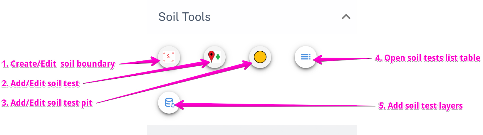
These are tools essential for soil test related work, including editing of soil tests and adding soil data. They include:
| Number | Tool Name | Icon on Map | Description |
|---|---|---|---|
| 1 | Create/Edit soil boundary tool | Create or edit soil boundary polygons | |
| 2 | Add/Edit soil test | Create or edit soil tests | |
| 3 | Add/Edit soil test pit | Create or edit soil test pits | |
| 4 | Open soil test list table | Open bottom drawer with list of all soil tests | |
| 5 | Add soil test layers | Add or remove soil related layers from the layer list on left drawer |
Septic tools
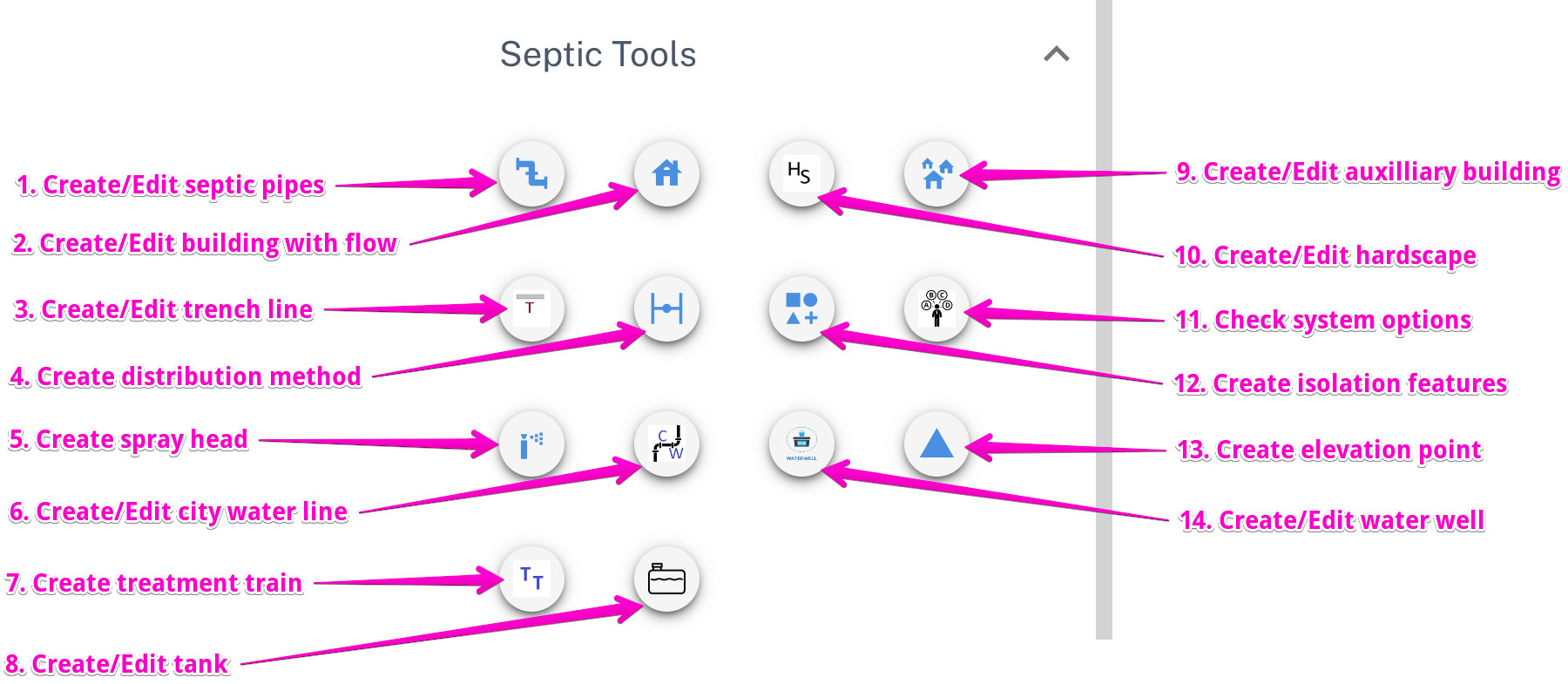
These are tools essential for creating core septic designs. They including creating building with flow, pipes and tanks, trenches etc:
| Number | Tool Name | Icon on Map | Description |
|---|---|---|---|
| 1 | Create/Edit septic pipes | Create or edit septic pipes which include sewer main, force main, distribution main, lateral, manifold etc | |
| 2 | Create/Edit building with flow | Create or edit building with flow | |
| 3 | Create/Edit trench line | Create or edit trench lines | |
| 4 | Create distribution method | Create distribution method | |
| 5 | Add spray head | Create spray heads. Learn more about this tool | |
| 6 | Create/Edit city water | Create or edit city water lines. | |
| 7 | Create treatment train | Create and manage group of tanks used together (treatment train). Learn more about this tool | |
| 8 | Create/Edit tanks | Create or edit tanks. Learn more about the available tank options | |
| 9 | Create/Edit auxiliary buildings | Create auxiliary buildings, that is, any other building which is not a building with flow | |
| 10 | Create/Edit hardscape | Create or edit hardscape | |
| 11 | Check system options | Open dialog to show system options for the current design | |
| 12 | Create isolation features | Create or edit isolation features | |
| 13 | Create/Edit elevation points | Create or edit elevation features on the map. Learn more about this tool | |
| 14 | Create/Edit water well | Create or edit water well points |